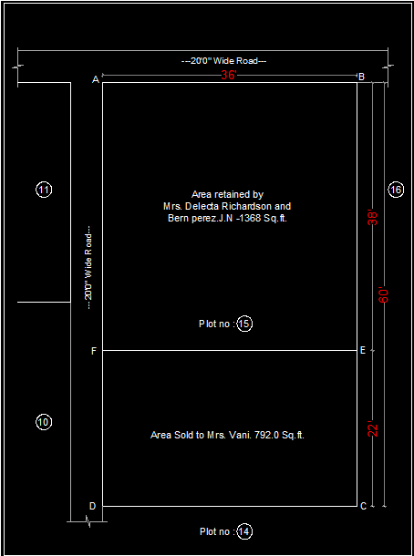
Sub division drawing : A subdivision drawing (or subdivision plan) is a detailed, professionally prepared drawing that outlines the division of a larger parcel of land into smaller lots for development. These drawings are essential for guiding the construction of residential, commercial, or industrial subdivisions. They are used by local authorities, engineers, developers, and surveyors to assess and approve the proposed development. The drawing usually includes information about boundaries, infrastructure, utilities, and compliance with zoning laws. Here’s an overview of the key components and details typically included in a subdivision drawing: 1. Property Boundaries Lot Lines: The drawing clearly shows the boundaries of the land parcel, including the division of the land into smaller lots. Lot lines separate individual lots from one another. Easements: These are areas where public or private utilities or other services are permitted, like drainage or power lines. Easements are typically shown on the drawing with specific notations. 2. Lot Dimensions and Areas Lot Sizes: Each lot within the subdivision will be labeled with its area (usually in square feet or acres) and may include length and width dimensions. Lot Numbers: Each individual lot in the subdivision is typically numbered or labeled for easy identification. 3. Streets and Roads Street Layout: The streets and roads within the subdivision are shown, including existing roads that will be incorporated and new roads that will be built. These are typically labeled with street names. Street Widths: Information on the width of streets and any proposed sidewalks or curbs. Road Grades and Slopes: In some cases, the drawing will also show the gradient of the streets (whether they slope up or down) to ensure proper drainage and accessibility. 4. Utilities and Infrastructure Water Supply: The location of water lines and hydrants, showing how each lot will be connected to the public or private water system. Sewer System: A layout of sewer lines, drains, or septic systems if applicable. Electrical and Gas Lines: Information on the location of underground or overhead electrical lines and any gas lines running through the area. Stormwater Management: This includes storm drains, retention ponds, and other systems to manage runoff and prevent flooding. 5. Zoning Information Zoning Designations: The subdivision drawing will often include the zoning classifications of the area. This indicates whether the subdivision is residential, commercial, mixed-use, etc. Setbacks: Setbacks are the minimum distance required between the property boundary and any buildings or structures. These can be shown on the drawing to ensure compliance with zoning codes. 6. Topography Contour Lines: Contour lines show the natural topography of the land, indicating slopes, hills, valleys, and flat areas. This is important for drainage planning and understanding how the subdivision will interact with the natural environment. Existing Features: Natural features like streams, wetlands, trees, and rocks may be shown, and any required conservation areas will be designated. 7. Land Use and Development Building Lots: The exact placement of each building lot is indicated, showing where homes, commercial buildings, or other structures will be located. Common Areas: If there are any communal or shared spaces within the subdivision (e.g., parks, green spaces, recreational areas), these will be marked as such. 8. Drainage Systems Stormwater Drainage: The drawing will include a plan for how water will drain from the subdivision to prevent flooding, including culverts, drains, and retention or detention basins. Runoff Paths: It will indicate where water will flow and how it will be channeled, either toward public drainage systems or natural areas like streams or lakes. 9. Access and Entry Points Entrances/Exits: The drawing will show how vehicles and pedestrians will enter and exit the subdivision, including access points from surrounding roads or highways. Pedestrian Pathways: Some subdivision plans also include walking paths or sidewalks for pedestrian access within the development. 10. Proposed Landscaping Landscaping Plans: In some subdivision drawings, landscaping plans are provided that include the types of trees, shrubs, grass, and other plants that will be used to improve the aesthetic quality of the development. Buffer Zones: These are areas of vegetation or fencing placed to reduce noise or visual impact for neighbors. 11. Legal and Surveying Information Surveyor's Seal and Signature: A licensed surveyor's seal will often appear on the drawing, confirming its accuracy and authenticity. Title Block: This includes important information such as the date of the drawing, the names of the property owners, the name of the subdivision, and the scale of the map. Scale: The scale is crucial for understanding the proportions of the drawing. Subdivision plans are usually drawn to a scale such as 1:100 or 1:200 (meaning 1 unit on the drawing represents 100 or 200 units in reality). 12. Environmental Considerations Flood Zones: If any parts of the subdivision are in a flood-prone area, this will be indicated on the drawing. Environmental Protection Areas: Areas that are protected due to their environmental importance (e.g., wetlands, wildlife habitats) will be clearly marked. 13. Phasing (for Larger Developments) Phased Development: If the subdivision is being developed in phases, the drawing might show the planned progression of construction, highlighting which sections will be developed first, second, etc. 14. Street Lighting and Signage Lighting Plan: Locations of street lights and signage within the subdivision, which are essential for both safety and navigation. Street Signs: Placement of street name signs and any other relevant traffic signs. Conclusion Subdivision drawings are an essential part of the land development process, as they provide a detailed, organized layout of how a piece of land will be divided, developed, and served by infrastructure. These drawings must comply with local zoning laws and regulations and are usually required as part of the permit application process for new developments. Depending on the scale of the subdivision and the complexity of the development, these drawings can vary in detail, but they will always serve the purpose of guiding the construction process, ensuring proper planning, and meeting legal and safety requirements. www.bechennai.com. Mobile no: 888 333 33 22.

This is your website preview.
Currently it only shows your basic business info. Start adding relevant business details such as description, images and products or services to gain your customers attention by using Boost 360 android app / iOS App / web portal.
Sub division drawing : A subdivision drawing (or s...
2025-03-10T07:02:41
Sub division drawing : A subdivision drawing (or subdivision plan) is a detailed, professionally prepared drawing that outlines the division of a larger parcel of land into smaller lots for development. These drawings are essential for guiding the construction of residential, commercial, or industrial subdivisions. They are used by local authorities, engineers, developers, and surveyors to assess and approve the proposed development. The drawing usually includes information about boundaries, infrastructure, utilities, and compliance with zoning laws. Here’s an overview of the key components and details typically included in a subdivision drawing: 1. Property Boundaries Lot Lines: The drawing clearly shows the boundaries of the land parcel, including the division of the land into smaller lots. Lot lines separate individual lots from one another. Easements: These are areas where public or private utilities or other services are permitted, like drainage or power lines. Easements are typically shown on the drawing with specific notations. 2. Lot Dimensions and Areas Lot Sizes: Each lot within the subdivision will be labeled with its area (usually in square feet or acres) and may include length and width dimensions. Lot Numbers: Each individual lot in the subdivision is typically numbered or labeled for easy identification. 3. Streets and Roads Street Layout: The streets and roads within the subdivision are shown, including existing roads that will be incorporated and new roads that will be built. These are typically labeled with street names. Street Widths: Information on the width of streets and any proposed sidewalks or curbs. Road Grades and Slopes: In some cases, the drawing will also show the gradient of the streets (whether they slope up or down) to ensure proper drainage and accessibility. 4. Utilities and Infrastructure Water Supply: The location of water lines and hydrants, showing how each lot will be connected to the public or private water system. Sewer System: A layout of sewer lines, drains, or septic systems if applicable. Electrical and Gas Lines: Information on the location of underground or overhead electrical lines and any gas lines running through the area. Stormwater Management: This includes storm drains, retention ponds, and other systems to manage runoff and prevent flooding. 5. Zoning Information Zoning Designations: The subdivision drawing will often include the zoning classifications of the area. This indicates whether the subdivision is residential, commercial, mixed-use, etc. Setbacks: Setbacks are the minimum distance required between the property boundary and any buildings or structures. These can be shown on the drawing to ensure compliance with zoning codes. 6. Topography Contour Lines: Contour lines show the natural topography of the land, indicating slopes, hills, valleys, and flat areas. This is important for drainage planning and understanding how the subdivision will interact with the natural environment. Existing Features: Natural features like streams, wetlands, trees, and rocks may be shown, and any required conservation areas will be designated. 7. Land Use and Development Building Lots: The exact placement of each building lot is indicated, showing where homes, commercial buildings, or other structures will be located. Common Areas: If there are any communal or shared spaces within the subdivision (e.g., parks, green spaces, recreational areas), these will be marked as such. 8. Drainage Systems Stormwater Drainage: The drawing will include a plan for how water will drain from the subdivision to prevent flooding, including culverts, drains, and retention or detention basins. Runoff Paths: It will indicate where water will flow and how it will be channeled, either toward public drainage systems or natural areas like streams or lakes. 9. Access and Entry Points Entrances/Exits: The drawing will show how vehicles and pedestrians will enter and exit the subdivision, including access points from surrounding roads or highways. Pedestrian Pathways: Some subdivision plans also include walking paths or sidewalks for pedestrian access within the development. 10. Proposed Landscaping Landscaping Plans: In some subdivision drawings, landscaping plans are provided that include the types of trees, shrubs, grass, and other plants that will be used to improve the aesthetic quality of the development. Buffer Zones: These are areas of vegetation or fencing placed to reduce noise or visual impact for neighbors. 11. Legal and Surveying Information Surveyor's Seal and Signature: A licensed surveyor's seal will often appear on the drawing, confirming its accuracy and authenticity. Title Block: This includes important information such as the date of the drawing, the names of the property owners, the name of the subdivision, and the scale of the map. Scale: The scale is crucial for understanding the proportions of the drawing. Subdivision plans are usually drawn to a scale such as 1:100 or 1:200 (meaning 1 unit on the drawing represents 100 or 200 units in reality). 12. Environmental Considerations Flood Zones: If any parts of the subdivision are in a flood-prone area, this will be indicated on the drawing. Environmental Protection Areas: Areas that are protected due to their environmental importance (e.g., wetlands, wildlife habitats) will be clearly marked. 13. Phasing (for Larger Developments) Phased Development: If the subdivision is being developed in phases, the drawing might show the planned progression of construction, highlighting which sections will be developed first, second, etc. 14. Street Lighting and Signage Lighting Plan: Locations of street lights and signage within the subdivision, which are essential for both safety and navigation. Street Signs: Placement of street name signs and any other relevant traffic signs. Conclusion Subdivision drawings are an essential part of the land development process, as they provide a detailed, organized layout of how a piece of land will be divided, developed, and served by infrastructure. These drawings must comply with local zoning laws and regulations and are usually required as part of the permit application process for new developments. Depending on the scale of the subdivision and the complexity of the development, these drawings can vary in detail, but they will always serve the purpose of guiding the construction process, ensuring proper planning, and meeting legal and safety requirements. www.bechennai.com. Mobile no: 888 333 33 22.
2025-03-10T07:02:41

Keywords
- 200 units
- subdivision drawing
- division drawing
- essential part
- subdivision plan
- map scale
- divided developed
- drawing represents 100
- drawing confirming
- construction highlighting
- marked 13 phasing
- hydrants showing
- proposed sidewalks
- typically shown
- typically labeled
- designated 7 land
- land parcel
- floodprone area
- surrounding roads
- existing roads
- individual lot
- subdivision plans
- meeting legal
- developments depending
- street lights
- 14 street lighting
- planned progression
- environmental importance
- protected due
- property owners
- neighbors 11 legal
- visual impact
- reduce noise
- aesthetic quality
- walking paths
- lakes 9 access
- prevent flooding
- shared spaces
- exact placement
- natural topography
- ensure compliance
- property boundary
- setbacks setbacks
- manage runoff
- septic systems
- square feet
- key components
- industrial subdivisions
- larger parcel
- natural areas
- flat areas
- proposed development
- drainage planning
- typically numbered
- building lot
- accessibility 4 utilities
- private utilities
- pedestrian access
- access points
- culverts drains
- applicable electrical
- smaller lots
- water lines
- zoning classifications
- includes information
- residential commercial
- drawing subdivision plans
- public drainage systems
- roads street layout
- boundaries infrastructure utilities
- land development process
- areas lot sizes
- infrastructure water supply
- includes important information
- development building lots
- required conservation areas
- homes commercial buildings
- area stormwater management
- ensure proper drainage
- power lines easements
- licensed surveyors seal
- streams wetlands trees
- located common areas
- development buffer zones
- residential commercial mixeduse
- details typically included
- detailed organized layout
- minimum distance required
- overhead electrical lines
- sewer lines drains
- highways pedestrian pathways
- entry points entrancesexits
- gas lines information
- local zoning laws
- zoning laws heres
- gas lines running
- permit application process
- wetlands wildlife habitats
- authenticity title block
- trees shrubs grass
- curbs road grades
Submit Your Enquiry